
EUREKA is Pioneering the Planning and Integration of Vertiports into Urban Airspace
The EUREKA project, funded by the SESAR JU and led by EUROCONTROL, aims to accelerate the integration of vertiports into the European airspace and to ensure a structured and efficient foundation for Innovative Air Mobility (IAM). The development of a functional Vertiport ecosystem is challenging, as Europe has little experience with innovative air mobility in low-altitude urban airspace. Limited reference materials and technical solutions further complicate the process, making it necessary to build from the ground up. In addition, the integration of vertiports into existing airspace structures requires careful coordination.
To address these complexities, EUREKA brings together 35 industry partners working to create a scalable, efficient and safe basis for vertiport operations. As the first SESAR project dedicated to this field, it plays a pioneering role in extending the current airspace management framework to accommodate vertiports. Still in its three-year development phase, the project's efforts will shape the future of innovative air mobility in Europe through four core solutions:
Arrival & Departure Procedures
A core challenge in Innovative Air Mobility (IAM) is seamlessly integrating vertiports into urban environments and existing airspace. The EUREKA project addresses this by developing adaptable procedures for approach, departure, and en-route flight paths of crewed VTOL-capable aircraft (VCA) also known as eVTOL. To ensure smooth operations, vertiports must be fully integrated into U-space, with real-time status updates accessible to all users. This project is establishing performance-based requirements that support both initial segregated operations and the long-term vision of fully integrated (un)crewed VCA flights.
Collaborative Traffic Management
EUREKA's Vertiport Collaborative Traffic Management system optimizes resource use and capacity at vertiports by centralizing key airside data like availability and schedules. It also helps manage U-space airspace constraints through Corridor Management, enhancing operational efficiency and integration within the broader U-space ecosystem.
Disruption & Emergency Management
By developing strategies to handle disruptive UAS and crewed VCAs in contingency situations, the project enhances vertiport resilience. This includes tactical adjustments to U-space airspace and the creation of agreements and operational documents to ensure effective responses to emergencies and disruptions.
Network Flow, Capacity & Operational Management
To ensure efficient coordination across multiple vertiports, EUREKA introduces the Vertiport Network Manager. This system plays a key role in monitoring and managing vertiports within both controlled and uncontrolled airspace, as well as those integrated with existing airports. By optimizing traffic flow and capacity allocation, ertiport Network Manager enhances overall airspace efficiency, improves airport throughput, and ensures seamless integration with existing ATM processes. This contributes to a safer, more sustainable IAM ecosystem, reinforcing vertiports as essential components of future urban air mobility.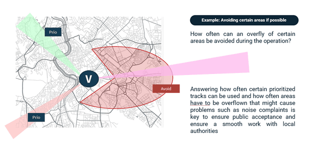
Unisphere’s contribution to the project
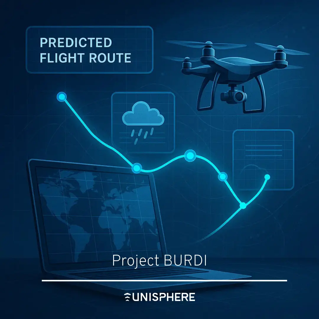
Unisphere is involved in two developments within the EUREKA project. On the one hand, Unisphere is supporting the airspace integration of Vertiports in the urban environment, with a focus on understanding the wind effects on the different head/tail/cross wind limits of certain eVTOL types, which have to be considered for the planning of approach and departure tracks. The EASA prototype specification for Vertiports describes track usability of 95%. This means that the combination of approach and departure paths (if multiple ones exist) should have an availability of 95% or greater.
Unisphere has developed an approach that uses historical weather data and track design to analyze how wind 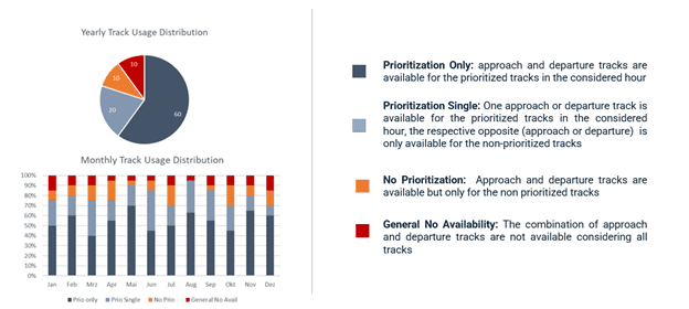 direction and strength affects availability. This is done by assessing, on an hourly basis, whether the wind conditions are within the eVTOL envelope, and if not, the respective track (either in the approach or departure direction) is classified as unavailable. Furthermore, the concept also takes into account the fact that from an urban planning perspective, some tracks may be prioritized while others are not, which may be due to noise reasons, airspace structure or environmental aspects that are considered by the various stakeholders involved in the planning phase.
The track usability analysis also addresses this challenge by providing a more detailed assessment of how often the prioritized tracks are available and how often a non-prioritized track must be used.
In addition to the solution described above, which supports the planning phase, Unisphere has also worked on concepts and regulatory work in the operational phase. The main focus is on the integration of U-Space services, in particular the weather information service, into eVTOL operations. Therefore, the integration of a weather information service with the local USSP is defined and adapted to serve the workflow of flight approvals using U-Space, but also the Vertiport is considered as an additional actor in the U-Space ecosystem as a new source of weather data that can be fed into the data stream from the USSP to the drone and eVTOL operator.
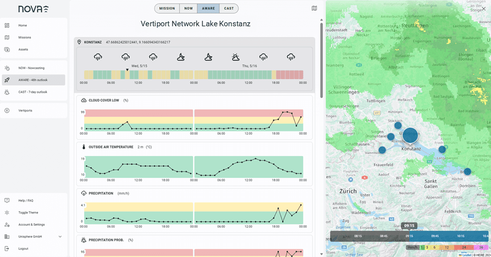
This exercise combines different regulatory frameworks (U-Space, eVTOL operations and Vertiport operations), which required a thorough assessment of how weather is used in the respective operations, resulting in a ConOps for Vertiports and their weather management as well as a proposal on how new sources of weather data can be used to improve the measurement points in a U-Space area.
